
The Landscape Architect's Process: Pre-Design
A great landscape design doesn’t just happen: it’s the result of a process. And our process is thorough and methodical, to deliver each client a beautiful, uniquely personal landscape they love to come home to. This is the first in a series of six posts describing the phases of our work:
The Pre-Design Phase
Before pencil ever hits sketch paper, we need to do some important data collection and analysis. The Pre-Design phase (which we call “PR” in our workflow) is the least creative part of the landscape architect’s work, but it’s surprisingly involved and arguably the most important.
Really, Pre-Design begins with our very first conversation with the client, when we ask questions about their landscaping wishes, needs, budget, and timeline in order to create the foundation of the design program that will serve as our guide or touchstone throughout the project.
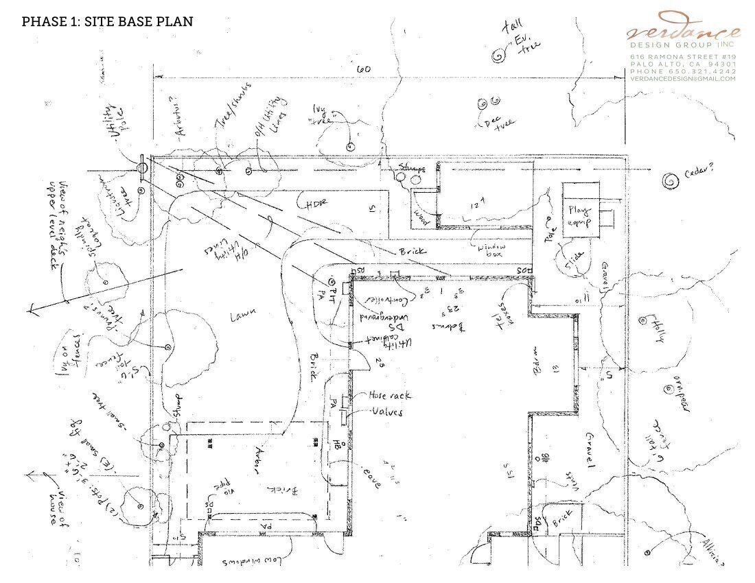
The site base plan, also known as the existing conditions plan or base map, provides the foundation for our future work.
The design program may also be informed by a landscape design consultation, during which we can experience the site first-hand, identify opportunities and challenges the owner may not be aware of, vet the feasibility of any ideas they may already have, and suggest appropriate design directions of our own.
With the basic design program defined, we can write a proposal that defines not only the scope of the services we will provide our client, but also what we will expect of them—accurate information, site access, timely decision-making, and payment in full, to name a few.
Once the proposal is accepted, we build on the information taken in so far, developing "idea books" and identifying precedents that capture the ideas, features, or styles that have been discussed so far. We often use Pinterest for this, although Houzz is excellent too.
Pre-Design encompasses a lot of data collection, and we begin by researching property records such as “plats” and city or county parcel maps which define the legal parameters of the site such as property lines, easements, and setbacks. These are sometimes treated casually by less-experienced landscapers, but can be incredibly important if there is a dispute over the ownership of a tree or fence, or a concern over the legality of a structure’s placement.
We then conduct site measurement, which may comprise retaining either a mapping service or a licensed land surveyor, to provide an accurate picture (literally) of the existing structures, vegetation, grades (slopes) and built and natural features, as well as property lines and even adjacent conditions such as overhanging trees. We the reconcile the site measurement with the parcel records to create a “base plan,” also known as a “base map,” of the existing conditions on and around the subject property.
Although it’s not technically measurement, in the Pre-Design phase we also capture the climatic character of a site, such as the patterns of wind, water, sun and shade (which may comprise discernable “microclimates”) as well as conditions such as noise or views. These observations form the basis of our site analysis, the part of the PR phase when we define areas that will—and won’t—favor certain elements of our design program. For instance, a steep grade probably won’t be the best place for a swimming pool.
Our clients are often surprised by how much work we perform before we even begin exploring design concepts. But there is no end of time-worn sayings—”well begun is half done,” “measure twice, cut once,” “begin with the end in mind,” and so on—to validate the fact that conscientious preparation allows us to create our best landscape architecture in the phases that follow.
Next, we’ll discuss the Schematic Design phase, in which functions and relationships are explored as the design program comes to life.